Looking for design inspiration? Browse our curated collections!

Boundary: Bleed area may not be visible.

The watermark at the lower right corner of the image will not appear on the final product.
Inside Message (Optional)
Inside View

by Paul Fearn
$6.45
Quantity
The more you buy... the more you save.
Orientation
Image Size
Product Details
Our greeting cards are 5" x 7" in size and are produced on digital offset printers using 100 lb. paper stock. Each card is coated with a UV protectant on the outside surface which produces a semi-gloss finish. The inside of each card has a matte white finish and can be customized with your own message up to 500 characters in length. Each card comes with a white envelope for mailing or gift giving.
Design Details
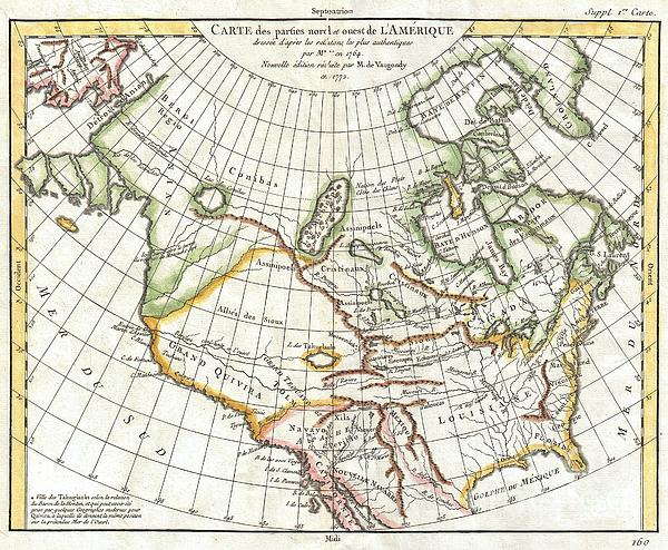
A truly remarkable 1772 map of North America by Robert de Vaugondy. Based upon an earlier map of the region by Thomas Engel, this is a fascinating... more
Ships Within
2 - 3 business days
Average Rating (4.84 Stars):


Neptune Ofthesea
April 21st, 2024

The wave has come, The sun is gone. Who rides the wave Runs the sun brave.
DANIELA MILLER
April 20th, 2024

I love it 😍 this Sun ☀️ Portal Sending Sun ☀️ cards to everyone Thank you 🙏 soo much 😘
Rita Tolbert
April 20th, 2024

Very professional absolute beautiful artristy by a gifted artist so very well pleased
Janie McKinley
April 19th, 2024

I love this greeting card with the old-fashioned outdoor dinner photo. Thank you for making it available.
Yaroslav Wow
April 19th, 2024

Thank you for your inspiration! It makes me a company for the whole day. And at nights it murmurs tranquillity.
Irene Gonzales
April 19th, 2024

love this greeting card
A truly remarkable 1772 map of North America by Robert de Vaugondy. Based upon an earlier map of the region by Thomas Engel, this is a fascinating examination of the general layout and waterways of North America – especially in the west. Curiously does not specifically show a Northwest Passage, but leaves clear the possibility that one such passage may indeed exist. Rivers and lakes extending from the eastern part of the continent almost, but never quite meet their counterparts from the west. While the east is displayed with reasonable accuracy, the cartography of the western part of North America is almost entirely conjectural and based upon early reports from Jesuit missionaries. Six largely mythical river systems extend inland from the Pacific or, as it appears on this map, “Mer du Sud”. Several meet with enormous and interesting mythical lakes. The northern most of these is Lake Conibas, the center of a supposed lake region that first appeared in Mercator’s 1569 map of Ame...
My passion is Photography and Aviation or is that Aviation and Photography ! I hope you enjoy my photographs.

Our return policy is very simple:
If you're not happy with a purchase that you made on FineArtAmerica.com, for any reason, you can return it to us within 30 days of the order date. As soon as it arrives, we'll issue a full refund for the entire purchase price. Please note - Fine Art America does not reimburse the outgoing or return shipping charges unless the return is due to a defect in quality.
Fine Art America sells thousands of pieces of artwork each month - all with a 100% money-back guarantee. We take great pride in the fact that hundreds of thousands of artists have chosen Fine Art America to fulfill their orders, and we look forward to helping you select your next piece!
All greeting cards ship from our production facility within 2 - 3 business days of your order.
$6.45


There are no comments for 1772 Vaugondy Diderot Map of North America and the Northwest Passage. Click here to post the first comment.