20% off all products! Sale ends tonight at midnight EST.
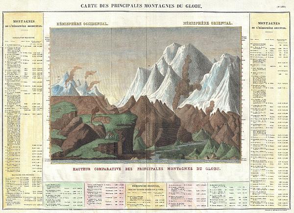
 And The Mountains Of The Eastern Hemisphere ( On The Right ). Also Includes The Relative Elevations Of Important Cities Greeting Card featuring the photograph 1825 Carez Comparative Map or Chart of the Worlds Great Mountains by Paul Fearn")
Boundary: Bleed area may not be visible.

The watermark at the lower right corner of the image will not appear on the final product.
Inside Message (Optional)
Inside View

by Paul Fearn
Regular Price: $6.45
20% Off (Sale Ends in 3 Hours)
$5.16
Quantity
The more you buy... the more you save.
Orientation
Image Size
Product Details
Our greeting cards are 5" x 7" in size and are produced on digital offset printers using 100 lb. paper stock. Each card is coated with a UV protectant on the outside surface which produces a semi-gloss finish. The inside of each card has a matte white finish and can be customized with your own message up to 500 characters in length. Each card comes with a white envelope for mailing or gift giving.
Design Details
This is a stunning 1825 comparative chart of the world’s mountains. Divided into the Western Hemisphere mountains ( on the left ) and the mountains... more
Ships Within
2 - 3 business days
Average Rating (4.84 Stars):


Elaine Brown
April 17th, 2024

Will use as a Christmas card this year!
Elaine Brown
April 17th, 2024

Will use this at Christmas time!
Elaine Brown
April 17th, 2024

Will use this card for a relatives birthday, as she loves wolves!
Kelly Hoffmann
April 17th, 2024

Ok card
Valerie Charles
April 17th, 2024

Lovely card, recipient very pleased
Valerie Charles
April 17th, 2024

Lovely card
This is a stunning 1825 comparative chart of the world’s mountains. Divided into the Western Hemisphere mountains ( on the left ) and the mountains of the Eastern Hemisphere ( on the right ). Also includes the relative elevations of important cities, monuments, etc. Unlike most comparative charts issued in the mid 19th century, this chart includes a reference table as part of the map itself. Lists Dalhgari, in Nepal, as the world’s tallest mountain, but also features smaller mountains that today serve as sky resorts such as Mt. Mansfield and Killington in Vermont, Mt. Monandnock and Mt. Washington in New Hampshire and Saddleback in Massachusetts. This was originally published in the 1825 French Edition of Carey & Lea’s 1822 A Complete Historical...American Atlas, entitled Atlas Géographique. Statistique, Historique et Chronologique des Deux-Amériques et des îles adjacentes. It was edited and published by Jean Alexandre Buchon.
My passion is Photography and Aviation or is that Aviation and Photography ! I hope you enjoy my photographs.

Our return policy is very simple:
If you're not happy with a purchase that you made on FineArtAmerica.com, for any reason, you can return it to us within 30 days of the order date. As soon as it arrives, we'll issue a full refund for the entire purchase price. Please note - Fine Art America does not reimburse the outgoing or return shipping charges unless the return is due to a defect in quality.
Fine Art America sells thousands of pieces of artwork each month - all with a 100% money-back guarantee. We take great pride in the fact that hundreds of thousands of artists have chosen Fine Art America to fulfill their orders, and we look forward to helping you select your next piece!
All greeting cards ship from our production facility within 2 - 3 business days of your order.
$5.16


There are no comments for 1825 Carez Comparative Map or Chart of the Worlds Great Mountains. Click here to post the first comment.