Looking for design inspiration? Browse our curated collections!

Boundary: Bleed area may not be visible.

Inside Message (Optional)
Inside View
$30.00
Quantity
The more you buy... the more you save.
Orientation
Image Size
Product Details
Our greeting cards are 5" x 7" in size and are produced on digital offset printers using 100 lb. paper stock. Each card is coated with a UV protectant on the outside surface which produces a semi-gloss finish. The inside of each card has a matte white finish and can be customized with your own message up to 500 characters in length. Each card comes with a white envelope for mailing or gift giving.
Design Details
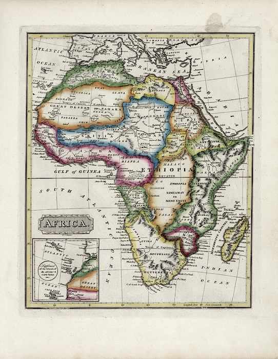
Map of Africa. 19th-century map of the continent of Africa, published in 1817 by US cartographer Fielding Lucas, Jr (1781-1854). The coast of Africa... more
Ships Within
2 - 3 business days
Average Rating (4.84 Stars):


Sandra Johnson
April 18th, 2024

I fell in love with this photo the day that Jan posted it. The cards are beautiful, frame able for a small space. I like that they have plenty of room for writing or doodling inside.
Cinder Rand
April 18th, 2024

This mermaid is a lovely gal and the colors are very zen and relaxing
Cinder Rand
April 18th, 2024

This card is fun. A lot going on but colors are lovely and brings joy
Cinder Rand
April 18th, 2024

A Diva indeed. What a happy card this is And I am a moon lover
Cinder Rand
April 18th, 2024

Sleeping on a dragon! My wish came true
Cinder Rand
April 18th, 2024

Love dragons this card was even better in person when it arrived.
Map of Africa. 19th-century map of the continent of Africa, published in 1817 by US cartographer Fielding Lucas, Jr (1781-1854). The coast of Africa and major rivers were mapped, but large areas of the interior remained unknown until the second half of the 19th century. Africa is here divided into fifteen regions. The names include Barbary, Tripoli, Egypt, the Sahara, Nigritia (Sudan), Nubia, Abyssinia, Darfur, Galla, Congo, Nimeamay (Niamey), the Houswaana, Caffreria, Monomotapa and Madagascar. An inset at lower left shows the Azores, Cape Verde, and Canary Islands. Published in 'A New and Elegant General Atlas' (Baltimore, 1817).

Science Photo Library (SPL) is the leading source of science images and footage. Sourced from scientific and medical experts, acclaimed photographers and renowned institutions, our content is unrivaled worldwide. Outstanding quality, accuracy and commitment to excellence are deeply embedded in our DNA. Science Photo Library inspires creative professionals and delivers engaging content of the highest quality for a wide range of clients in a variety of sectors. Visit sciencephoto.com for more information and stay connected on Twitter, LinkedIn, Instagram and Vimeo.

Our return policy is very simple:
If you're not happy with a purchase that you made on FineArtAmerica.com, for any reason, you can return it to us within 30 days of the order date. As soon as it arrives, we'll issue a full refund for the entire purchase price. Please note - Fine Art America does not reimburse the outgoing or return shipping charges unless the return is due to a defect in quality.
Fine Art America sells thousands of pieces of artwork each month - all with a 100% money-back guarantee. We take great pride in the fact that hundreds of thousands of artists have chosen Fine Art America to fulfill their orders, and we look forward to helping you select your next piece!
All greeting cards ship from our production facility within 2 - 3 business days of your order.
$30.00


There are no comments for Map Of Africa #6. Click here to post the first comment.