Looking for design inspiration? Browse our curated collections!

Boundary: Bleed area may not be visible.

The watermark at the lower right corner of the image will not appear on the final product.

by Paul Fearn
$25.00
Size
Image Size
Product Details
Purchase a tote bag featuring the photograph "1591 De Bry and Le Moyne Map of Florida and Cuba" by Paul Fearn. Our tote bags are made from soft, durable, poly-poplin fabric and include a 1" black strap for easy carrying on your shoulder. All seams are double-stitched for added durability. Each tote bag is machine-washable in cold water and is printed on both sides using the same image.
Design Details
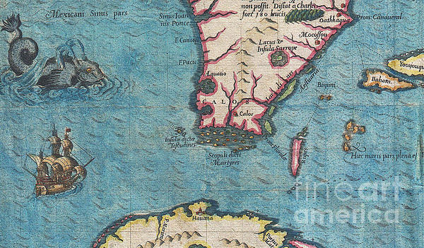
The most remarkable and important map, which has been preserved from the sixteenth century maps, of that part of the East Coast which lies between... more
Ships Within
2 - 3 business days
Average Rating (4.85 Stars):


Sandra Johnson
April 18th, 2024

I noted that the color came out differently on this size of bag, it is distinctly more purple. I happen to love that color also--the larger size has perfect color, exactly like the photo. I love both of my bags.
Sandra Johnson
April 18th, 2024

the bags are lovely, a nice weight, and this big one is perfect color wise.
Susan Miller
April 12th, 2024

Quite beautiful!
Lorraine Amer
April 9th, 2024

Have not received my Can’t send photo…. Have not received my purchase
Angel May
April 2nd, 2024

I sent it as a gift and she loves it. I have some of his original pieces. They take me away.
Nancy Rice
March 29th, 2024

This tote bag is gorgeous! I saw a picture of it and had to have it. The colors are just beautiful. The size is better than I expected, because it's larger than I had envisioned it. It is practical and functional as well as beautiful. I'm very happy with this purchase.
the most remarkable and important map, which has been preserved from the sixteenth century maps, of that part of the East Coast which lies between Cape Hatteras and Cape Florida … the first French map to show Florida … considered the most important map of Florida. - Johns Matthews Baxter A map of extraordinary rarity and seminal importance, this is one of the earliest and most influential maps of the American southeast ever published. Drawn by the French artist Jacques Le Moyne de Morgues c. 1565 and published by Theodore de Bry in 1591, this magnificent map details the Florida peninsula and Carolina coast from Cuba to the Bahamas, to “Prom Terra flag” or, as it is known today, Cape Lookout near Beaufort, North Carolina. The fascinating story of this map begins with the ambitions of the influential Huguenot Admiral Gaspard de Coligny. De Coligny, desirous of a French foothold on the American mainland sent the talented navigator Jean Ribaut to establish a colony. In 1562 Ribaut...
My passion is Photography and Aviation or is that Aviation and Photography ! I hope you enjoy my photographs.

Our return policy is very simple:
If you're not happy with a purchase that you made on FineArtAmerica.com, for any reason, you can return it to us within 30 days of the order date. As soon as it arrives, we'll issue a full refund for the entire purchase price. Please note - Fine Art America does not reimburse the outgoing or return shipping charges unless the return is due to a defect in quality.
Fine Art America sells thousands of pieces of artwork each month - all with a 100% money-back guarantee. We take great pride in the fact that hundreds of thousands of artists have chosen Fine Art America to fulfill their orders, and we look forward to helping you select your next piece!
All tote bags ship from our production facility within 2 - 3 business days of your order.
$25.00


There are no comments for 1591 De Bry and Le Moyne Map of Florida and Cuba. Click here to post the first comment.