Looking for design inspiration? Browse our curated collections!

Boundary: Bleed area may not be visible.

$41.95
Model
Case Style
Orientation
Image Size
Product Details
Map Of London #1 iPhone x case by Library Of Congress, Geography And Map Division. Protect your iPhone X with an impact-resistant, slim-profile, hard-shell case. The image is printed directly onto the case and wrapped around the edges for a beautiful presentation. Simply snap the case onto your iPhone X for instant protection and direct access to all of the phone's features!
Design Details
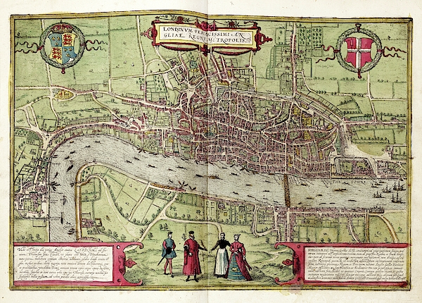
Map of London. 16th-century map of Tudor London, titled 'Londinum Feracissimi Angliae Regni Metropolis'. In the top corners are Tudor (left) and City... more
Ships Within
3 - 4 business days
Protect your iPhone X with an impact-resistant, slim-profile, hard-shell case. The image is printed directly onto the case and wrapped around the edges for a beautiful presentation. Simply snap the case onto your iPhone X for instant protection and direct access to all of the phone's features!
Average Rating (4.69 Stars):


Suzanne Hale
April 19th, 2024

Looks fantastic, fits my phone perfectly - love it!
Suzanne Hale
April 19th, 2024

Fits my phone perfectly and looks fantastic.
Hannah Gallegos
April 19th, 2024

Looks just as pictured!! Heavy duty case is perfect and fits snug! Detail in person is far better! I did a Snapchat selfie so the color is a little off in my image. But I love it! Good quality and better pricing for exactly what I want
Barbara Prevost
April 18th, 2024

I am concerned because I have not received it yet, nor a notification of Shipping. Please check on this for me??
Kenneth Muir
April 18th, 2024

Beautiful case well built certainly worth the price
Mike Cassady
April 17th, 2024

I like the case one of a kind
Map of London. 16th-century map of Tudor London, titled 'Londinum Feracissimi Angliae Regni Metropolis'. In the top corners are Tudor (left) and City (right) coats-of-arms. Latin inscriptions (bottom corners) describe the city economy. Manor houses link the city with the royal court at Westminster (left). London Bridge (centre right) leads to Southwark. The spire of St Paul's Cathedral (destroyed 1561) is visible. The vignette (lower centre) shows local dress. This is a 1612 edition of a map first published in volume 1 (1572) of the city atlas 'Civitates orbis terrarum'. This atlas was edited by Georg Braun (c.1540-1622) and largely engraved by Franz Hogenberg.

Science Photo Library (SPL) is the leading source of science images and footage. Sourced from scientific and medical experts, acclaimed photographers and renowned institutions, our content is unrivaled worldwide. Outstanding quality, accuracy and commitment to excellence are deeply embedded in our DNA. Science Photo Library inspires creative professionals and delivers engaging content of the highest quality for a wide range of clients in a variety of sectors. Visit sciencephoto.com for more information and stay connected on Twitter, LinkedIn, Instagram and Vimeo.

Our return policy is very simple:
If you're not happy with a purchase that you made on FineArtAmerica.com, for any reason, you can return it to us within 30 days of the order date. As soon as it arrives, we'll issue a full refund for the entire purchase price. Please note - Fine Art America does not reimburse the outgoing or return shipping charges unless the return is due to a defect in quality.
Fine Art America sells thousands of pieces of artwork each month - all with a 100% money-back guarantee. We take great pride in the fact that hundreds of thousands of artists have chosen Fine Art America to fulfill their orders, and we look forward to helping you select your next piece!
All iphone x cases ship from our production facility within 3 - 4 business days of your order.
$41.95


Irina Sztukowski
Congratulations on your sale!
Sunil Kapadia
Congratulations !
Gene Parks
Congratulations on your recent sale!!