20% off all products! Sale ends tonight at midnight EST.

Boundary: Bleed area may not be visible.

The watermark at the lower right corner of the image will not appear on the final product.

by Paul Fearn
Regular Price: $27.00
20% Off (Sale Ends in 10 Hours)
$21.60
Model
Case Style
Orientation
Image Size
Product Details
1762 Janvier Map of North America and South America iPhone 11 case by Paul Fearn. Protect your iPhone 11 with an impact-resistant, slim-profile, hard-shell case. The image is printed directly onto the case and wrapped around the edges for a beautiful presentation. Simply snap the case onto your iPhone 11 for instant protection and direct access to all of the phone's features!
Design Details
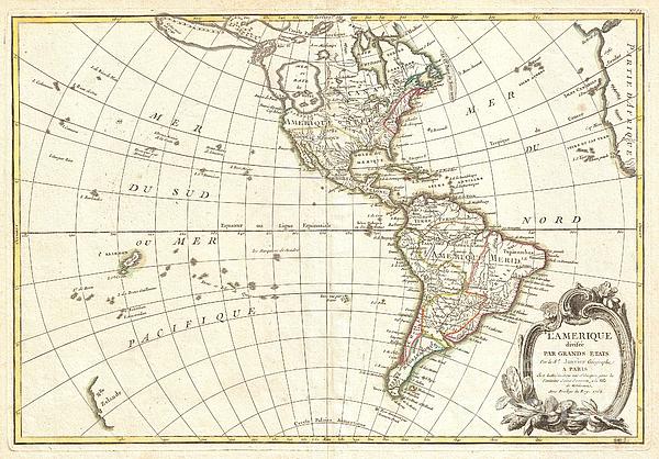
An altogether fascinating map of North America and South America by Jean Janvier dating to 1862. Covers both continents from the Antarctic Circle to... more
Ships Within
3 - 4 business days
Protect your iPhone 11 with an impact-resistant, slim-profile, hard-shell case. The image is printed directly onto the case and wrapped around the edges for a beautiful presentation. Simply snap the case onto your iPhone 11 for instant protection and direct access to all of the phone's features!
Average Rating (4.69 Stars):


Mike Cassady
April 17th, 2024

I like the case one of a kind
James Jordan
April 17th, 2024

Have not received the product as of yet. Still the scene is a great scene taking the Flat Irons ans Longs Peak. Beautiful!
James Jordan
April 17th, 2024

Great picture alas will have to return it as I omitted the right cellphone size cover.But fantastic picture. I really enjoy the scene.
Shawna Korth
April 15th, 2024

Love it!!!
Brenda Reeves
April 15th, 2024

Happy costumer, I received it today. Nelsonville is my hometown, so it’s very special. Thank you so much.
RICHARD SAVINO
April 14th, 2024

Great professional work. Thanks
An altogether fascinating map of North America and South America by Jean Janvier dating to 1862. Covers both continents from the Antarctic Circle to the arctic circle, extends westward to New Zealand and eastward as far as Africa and Spain. This map, which is heavily influenced by the theoretical mappings of Guillaume de l'Isle and Philippe Buache, went through several states of which this is the earliest and possibly the most interesting. By far the most interesting aspects of this map deal with Janvier's treatment of the largely unexplored Pacific Northwest. A magnificent sea, called the Sea of the West or in this case the Baye de L'Ouest, occupies the greater part of the northwestern part of the continent. This body of water, alternatively called the Sea of the West or Mer de l'Ouest, was speculated by Philippe Buache and Guillaume De l'Isle in the early 18th century based upon wishful thinking, American Indian stories, and the somewhat questionable 16th century explorations of Jua...
My passion is Photography and Aviation or is that Aviation and Photography ! I hope you enjoy my photographs.

Our return policy is very simple:
If you're not happy with a purchase that you made on FineArtAmerica.com, for any reason, you can return it to us within 30 days of the order date. As soon as it arrives, we'll issue a full refund for the entire purchase price. Please note - Fine Art America does not reimburse the outgoing or return shipping charges unless the return is due to a defect in quality.
Fine Art America sells thousands of pieces of artwork each month - all with a 100% money-back guarantee. We take great pride in the fact that hundreds of thousands of artists have chosen Fine Art America to fulfill their orders, and we look forward to helping you select your next piece!
All iphone 11 cases ship from our production facility within 3 - 4 business days of your order.
$21.60


There are no comments for 1762 Janvier Map of North America and South America . Click here to post the first comment.