20% off all products! Sale ends tonight at midnight EST.

Boundary: Bleed area may not be visible.

The watermark at the lower right corner of the image will not appear on the final product.

by Paul Fearn
Regular Price: $25.00
20% Off (Sale Ends in 19 Hours)
$20.00
Size
Image Size
Product Details
Purchase a tote bag featuring the photograph "1780 Raynal and Bonne Map of Louisiana Florida and Carolina" by Paul Fearn. Our tote bags are made from soft, durable, poly-poplin fabric and include a 1" black strap for easy carrying on your shoulder. All seams are double-stitched for added durability. Each tote bag is machine-washable in cold water and is printed on both sides using the same image.
Design Details
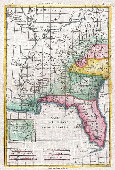
A fine example of Rigobert Bonne and G. Raynal’s 1780 map of Louisiana and Florida. Map corresponds to modern day Florida, Georgia, Alabama,... more
Ships Within
2 - 3 business days
Average Rating (4.85 Stars):


Colleen ONeill Nice
April 19th, 2024

Karen Cattel is a special artist and her whimsical art looks great on the two sturdy totes I purchased. One is a gift for a friend and the other is for me. I love them.
Janie McKinley
April 19th, 2024

I so appreciate being able to have this old-fashioned outdoor dinner scene on a tote bag. It is adorable. Thank you for making it available.
Sandra Johnson
April 18th, 2024

I noted that the color came out differently on this size of bag, it is distinctly more purple. I happen to love that color also--the larger size has perfect color, exactly like the photo. I love both of my bags.
Sandra Johnson
April 18th, 2024

the bags are lovely, a nice weight, and this big one is perfect color wise.
Susan Miller
April 12th, 2024

Quite beautiful!
Lorraine Amer
April 9th, 2024

Have not received my Can’t send photo…. Have not received my purchase
A fine example of Rigobert Bonne and G. Raynal’s 1780 map of Louisiana and Florida. Map corresponds to modern day Florida, Georgia, Alabama, Arkansas, Kentucky, Tennessee, North Carolina, South Carolina, Virginia and Louisiana. Offers considerable detail of the only tenuously explored interior, naming numerous American Indian tribes and villages including Apalachiola, Echicachae, Chaccoumas, Acansas, and many others. Of the colonies, only Florida, Georgia, North Carolina and South Carolina are evident. An inset in the lower left quadrant focuses on the upper Missouri River, which was of interest at the time as a possible water route to the Pacific. Drawn by R. Bonne for G. Raynal’s Atlas de Toutes les Parties Connues du Globe Terrestre, Dressé pour l'Histoire Philosophique et Politique des Établissemens et du Commerce des Européens dans les Deux Indes .
My passion is Photography and Aviation or is that Aviation and Photography ! I hope you enjoy my photographs.

Our return policy is very simple:
If you're not happy with a purchase that you made on FineArtAmerica.com, for any reason, you can return it to us within 30 days of the order date. As soon as it arrives, we'll issue a full refund for the entire purchase price. Please note - Fine Art America does not reimburse the outgoing or return shipping charges unless the return is due to a defect in quality.
Fine Art America sells thousands of pieces of artwork each month - all with a 100% money-back guarantee. We take great pride in the fact that hundreds of thousands of artists have chosen Fine Art America to fulfill their orders, and we look forward to helping you select your next piece!
All tote bags ship from our production facility within 2 - 3 business days of your order.
$20.00


There are no comments for 1780 Raynal and Bonne Map of Louisiana Florida and Carolina. Click here to post the first comment.