Looking for design inspiration? Browse our curated collections!

Boundary: Bleed area may not be visible.

The watermark at the lower right corner of the image will not appear on the final product.
Inside Message (Optional)
Inside View

by Paul Fearn
$6.45
Quantity
The more you buy... the more you save.
Orientation
Image Size
Product Details
Our greeting cards are 5" x 7" in size and are produced on digital offset printers using 100 lb. paper stock. Each card is coated with a UV protectant on the outside surface which produces a semi-gloss finish. The inside of each card has a matte white finish and can be customized with your own message up to 500 characters in length. Each card comes with a white envelope for mailing or gift giving.
Design Details
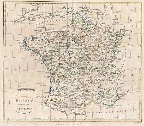
A fine 1799 map of France Divided into Provinces by the English map publisher Clement Cruttwell. France was organized into provinces until March 4,... more
Ships Within
2 - 3 business days
Average Rating (4.84 Stars):


Elaine Brown
April 17th, 2024

Will use as a Christmas card this year!
Elaine Brown
April 17th, 2024

Will use this at Christmas time!
Elaine Brown
April 17th, 2024

Will use this card for a relatives birthday, as she loves wolves!
Kelly Hoffmann
April 17th, 2024

Ok card
Valerie Charles
April 17th, 2024

Lovely card, recipient very pleased
Valerie Charles
April 17th, 2024

Lovely card
A fine 1799 map of France Divided into Provinces by the English map publisher Clement Cruttwell. France was organized into provinces until March 4, 1790, when the establishment of the department system superseded provinces. The change was an attempt to eradicate local loyalties based on feudal ownership of land and focus all loyalty on the central government in Paris. There were roughly 40 provinces in France before they were abolished. Maps displays all provinces, including the province of Île-de-France, the center of power during most of French history. Many atlas produced during this period thus included two maps of France, one in Provinces, and one in Departments. Includes parts adjacent Austrian Netherlands, Switzerland, Germany, Italy, and Spain. Includes rivers, political boundaries, important cities, ports and gulfs. Mountains and other topographical features shown by profile. Outline color and fine copper plate engraving in the minimalist English style prevalent in the late 1...
My passion is Photography and Aviation or is that Aviation and Photography ! I hope you enjoy my photographs.

Our return policy is very simple:
If you're not happy with a purchase that you made on FineArtAmerica.com, for any reason, you can return it to us within 30 days of the order date. As soon as it arrives, we'll issue a full refund for the entire purchase price. Please note - Fine Art America does not reimburse the outgoing or return shipping charges unless the return is due to a defect in quality.
Fine Art America sells thousands of pieces of artwork each month - all with a 100% money-back guarantee. We take great pride in the fact that hundreds of thousands of artists have chosen Fine Art America to fulfill their orders, and we look forward to helping you select your next piece!
All greeting cards ship from our production facility within 2 - 3 business days of your order.
$6.45


There are no comments for 1799 Clement Cruttwell Map of France in Provinces. Click here to post the first comment.