20% off all products! Sale ends tonight at midnight EST.

Boundary: Bleed area may not be visible.


by Paul Fearn
Regular Price: $25.00
20% Off (Sale Ends in 13 Hours)
$20.00
Size
Image Size
Product Details
Purchase a tote bag featuring the photograph "1857 U.S.C.S. Map of San Diego Bay, California" by Paul Fearn. Our tote bags are made from soft, durable, poly-poplin fabric and include a 1" black strap for easy carrying on your shoulder. All seams are double-stitched for added durability. Each tote bag is machine-washable in cold water and is printed on both sides using the same image.
Design Details
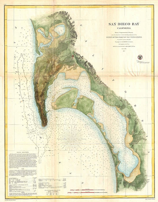
This is the most attractive map of San Diego Bay, California, to emerge from the work of the U.S. Coast Survey. Covers the Sand Diego area from False... more
Ships Within
2 - 3 business days
Average Rating (4.85 Stars):


Colleen ONeill Nice
April 19th, 2024

Karen Cattel is a special artist and her whimsical art looks great on the two sturdy totes I purchased. One is a gift for a friend and the other is for me. I love them.
Janie McKinley
April 19th, 2024

I so appreciate being able to have this old-fashioned outdoor dinner scene on a tote bag. It is adorable. Thank you for making it available.
Sandra Johnson
April 18th, 2024

I noted that the color came out differently on this size of bag, it is distinctly more purple. I happen to love that color also--the larger size has perfect color, exactly like the photo. I love both of my bags.
Sandra Johnson
April 18th, 2024

the bags are lovely, a nice weight, and this big one is perfect color wise.
Susan Miller
April 12th, 2024

Quite beautiful!
Lorraine Amer
April 9th, 2024

Have not received my Can’t send photo…. Have not received my purchase
This is the most attractive map of San Diego Bay, California, to emerge from the work of the U.S. Coast Survey. Covers the Sand Diego area from False Bay and the Valley of Las Yeguas southward past Mission Valley and San Diego city to San Diego Bay and the villages of La Punta and the Valley of Ohjia. Offers superb detail both inland and at sea. Inland detail includes topographical features, rivers, roads, and villages. Villages and cities, including San Diego, La Playa, New San Diego, and others, are detailed to the level of individual buildings. Nautical details include innumerable depth sounding, breakwaters, and notes on the Kelp Beds off the coast of Point Lonia. Lower left quadrant features textual sailing instructions as well as notes on the tides and a history of the chart. This cart was prepared under the supervision of A. D. Bache for inclusion in the 1857 edition of the Report of the Superintendent of the United States Coast Survey . The triangulation for this chart was acco...
My passion is Photography and Aviation or is that Aviation and Photography ! I hope you enjoy my photographs.

Our return policy is very simple:
If you're not happy with a purchase that you made on FineArtAmerica.com, for any reason, you can return it to us within 30 days of the order date. As soon as it arrives, we'll issue a full refund for the entire purchase price. Please note - Fine Art America does not reimburse the outgoing or return shipping charges unless the return is due to a defect in quality.
Fine Art America sells thousands of pieces of artwork each month - all with a 100% money-back guarantee. We take great pride in the fact that hundreds of thousands of artists have chosen Fine Art America to fulfill their orders, and we look forward to helping you select your next piece!
All tote bags ship from our production facility within 2 - 3 business days of your order.
$20.00


There are no comments for 1857 U.S.C.S. Map of San Diego Bay, California. Click here to post the first comment.