20% off all products! Sale ends tonight at midnight EST.

Boundary: Bleed area may not be visible.


by Paul Fearn
Regular Price: $25.00
20% Off (Sale Ends in 19 Hours)
$20.00
Size
Bottom Style
Image Size
Product Details
Dress it up, dress it down, or use it to stay organized while you're on the go. Our zip pouches can do it all. They're crafted with 100% poly-poplin fabric, double-stitched at the seams for extra durability, and include a durable metal zipper for securing your valuables.
Our zip pouches are available in three different sizes and with two different bottom styles: regular and t-bottom.
Design Details
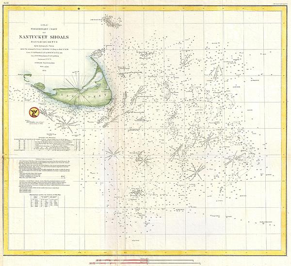
This beautiful and important sea chart or map depicts the waters immediately surrounding the island of Nantucket, Massachusetts, including Davis’... more
Care Instructions
Spot clean or dry clean only.
Ships Within
2 - 3 business days
Average Rating (4.36 Stars):


Rosemary Milazzo
April 14th, 2024

Absolutely love it!!! It is so beautiful and calms and relaxes me every time I look at it. Couldn’t be happier!
Maggie Brewner
April 13th, 2024

I was disappointed that the image on this pouch was not very clear. The zipper doesn't work real well, either.
Dolores Nadwondy
March 25th, 2024

Love this!
Dolores Nadwondy
March 25th, 2024

Great quality
Fred R Manthai
March 7th, 2024

Very attractive. I am very satisfied with this purchase.
Rachel Paschini
March 5th, 2024

Using as a wallet
This beautiful and important sea chart or map depicts the waters immediately surrounding the island of Nantucket, Massachusetts, including Davis’ Shoal, Old South Shoal, and others. Uncommon, highly significant, and often underappreciated, this 1854 map reveals an important stage in the charting of the shoals off Nantucket. Though the unpredictable waters off Nantucket were long a nemesis to sailing vessels on the important London – New York shipping routes, they had never been properly charted. The harsh conditions, including rapid unexpected swells and frequent heavy fog, contrived to make the hydrographic survey of the hazards south of Nantucket one of the most dangerous and challenging projects of the early Coast Survey. The first survey party to tackle this area was lead by the indomitable Lieutenant Commanding Charles H. Davis. Starting at Old South Shoal, a known danger, Davis worked his way southward and soon discovered “New South Shoal”, which is here renamed “Davis...
My passion is Photography and Aviation or is that Aviation and Photography ! I hope you enjoy my photographs.

Our return policy is very simple:
If you're not happy with a purchase that you made on FineArtAmerica.com, for any reason, you can return it to us within 30 days of the order date. As soon as it arrives, we'll issue a full refund for the entire purchase price. Please note - Fine Art America does not reimburse the outgoing or return shipping charges unless the return is due to a defect in quality.
Fine Art America sells thousands of pieces of artwork each month - all with a 100% money-back guarantee. We take great pride in the fact that hundreds of thousands of artists have chosen Fine Art America to fulfill their orders, and we look forward to helping you select your next piece!
All zip pouches ship from our production facility within 2 - 3 business days of your order.
$20.00


There are no comments for Coast Survey Nautical Chart or Map of Nantucket Massachusetts. Click here to post the first comment.