Looking for design inspiration? Browse our curated collections!

Boundary: Bleed area may not be visible.

$41.95
Model
Case Style
Orientation
Image Size
Product Details
Map Of The Mississippi River Galaxy s4 case by Library Of Congress, Geography And Map Division. Protect your Galaxy S4 with an impact-resistant, slim-profile, hard-shell case. The image is printed directly onto the case and wrapped around the edges for a beautiful presentation. Simply snap the case onto your Galaxy S4 for instant protection and direct access to all of the phone's features!
Design Details
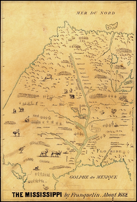
Map of the Mississippi River. Copy of the 17th-century map made in around 1682 by French cartographer Jean-Baptiste-Louis Franquelin. One of the... more
Ships Within
3 - 4 business days
Protect your Galaxy S4 with an impact-resistant, slim-profile, hard-shell case. The image is printed directly onto the case and wrapped around the edges for a beautiful presentation. Simply snap the case onto your Galaxy S4 for instant protection and direct access to all of the phone's features!

Back View

Angled Back View

Front View

Angled Front View

Side View
Average Rating (4.69 Stars):


Mike Cassady
April 17th, 2024

I like the case one of a kind
James Jordan
April 17th, 2024

Have not received the product as of yet. Still the scene is a great scene taking the Flat Irons ans Longs Peak. Beautiful!
James Jordan
April 17th, 2024

Great picture alas will have to return it as I omitted the right cellphone size cover.But fantastic picture. I really enjoy the scene.
Shawna Korth
April 15th, 2024

Love it!!!
Brenda Reeves
April 15th, 2024

Happy costumer, I received it today. Nelsonville is my hometown, so it’s very special. Thank you so much.
RICHARD SAVINO
April 14th, 2024

Great professional work. Thanks
Map of the Mississippi River. Copy of the 17th-century map made in around 1682 by French cartographer Jean-Baptiste-Louis Franquelin. One of the earliest maps of the Mississippi River, it was based on the expeditions of French-Canadian explorer Louis Jolliet who travelled down the Mississippi with Jacques Marquette in 1673. This map shows trees, animals, and names of the Indian nations and settlements. The map shows much of what was then French Louisiana, stretching north to Canada and the Arctic from the Gulf of Mexico (bottom). Florida is also marked, as is Lake Superior (upper right). Part of Mexico is at lower left.

Science Photo Library (SPL) is the leading source of science images and footage. Sourced from scientific and medical experts, acclaimed photographers and renowned institutions, our content is unrivaled worldwide. Outstanding quality, accuracy and commitment to excellence are deeply embedded in our DNA. Science Photo Library inspires creative professionals and delivers engaging content of the highest quality for a wide range of clients in a variety of sectors. Visit sciencephoto.com for more information and stay connected on Twitter, LinkedIn, Instagram and Vimeo.

Our return policy is very simple:
If you're not happy with a purchase that you made on FineArtAmerica.com, for any reason, you can return it to us within 30 days of the order date. As soon as it arrives, we'll issue a full refund for the entire purchase price. Please note - Fine Art America does not reimburse the outgoing or return shipping charges unless the return is due to a defect in quality.
Fine Art America sells thousands of pieces of artwork each month - all with a 100% money-back guarantee. We take great pride in the fact that hundreds of thousands of artists have chosen Fine Art America to fulfill their orders, and we look forward to helping you select your next piece!
All galaxy s4 cases ship from our production facility within 3 - 4 business days of your order.
$41.95


There are no comments for Map Of The Mississippi River. Click here to post the first comment.