Looking for design inspiration? Browse our curated collections!

Boundary: Bleed area may not be visible.

The watermark at the lower right corner of the image will not appear on the final product.
Inside Message (Optional)
Inside View

by Paul Fearn
$6.45
Quantity
The more you buy... the more you save.
Orientation
Image Size
Product Details
Our greeting cards are 5" x 7" in size and are produced on digital offset printers using 100 lb. paper stock. Each card is coated with a UV protectant on the outside surface which produces a semi-gloss finish. The inside of each card has a matte white finish and can be customized with your own message up to 500 characters in length. Each card comes with a white envelope for mailing or gift giving.
Design Details
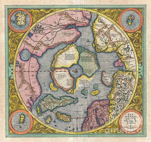
This is the second edition of Gerard Mercator's map of the North Pole or Arctic, one of the great cartographer's most interesting and important maps.... more
Ships Within
2 - 3 business days
Average Rating (4.84 Stars):


Neptune Ofthesea
April 21st, 2024

The wave has come, The sun is gone. Who rides the wave Runs the sun brave.
DANIELA MILLER
April 20th, 2024

I love it 😍 this Sun ☀️ Portal Sending Sun ☀️ cards to everyone Thank you 🙏 soo much 😘
Rita Tolbert
April 20th, 2024

Very professional absolute beautiful artristy by a gifted artist so very well pleased
Janie McKinley
April 19th, 2024

I love this greeting card with the old-fashioned outdoor dinner photo. Thank you for making it available.
Yaroslav Wow
April 19th, 2024

Thank you for your inspiration! It makes me a company for the whole day. And at nights it murmurs tranquillity.
Irene Gonzales
April 19th, 2024

love this greeting card
This is the second edition of Gerard Mercator's map of the North Pole or Arctic, one of the great cartographer's most interesting and important maps. Mercator's Arctic projection has its roots in his magnificent 1569 wall map of the world in which Mercator first introduces his revolutionary projection. As regards the Arctic, the difficulty with the Mercator Projection is that to accurately depict the Polar Regions, his map would have to be infinitely tall. Mercator compensated for this by included a polar projection, very similar to the map shown here, in the lower-left hand corner of his great map. This may rightly be considered to be the world's first specific map of the north pole. Mercator later reissued this map in an expanded format for his 1595 atlas. Following a number of important expeditions to the Arctic in subsequent 10 years, Mercator's successor Jodocus Hondius reissued the original 1595 map with a number of revolutionary and highly significant changes. Our survey of this...
My passion is Photography and Aviation or is that Aviation and Photography ! I hope you enjoy my photographs.

Our return policy is very simple:
If you're not happy with a purchase that you made on FineArtAmerica.com, for any reason, you can return it to us within 30 days of the order date. As soon as it arrives, we'll issue a full refund for the entire purchase price. Please note - Fine Art America does not reimburse the outgoing or return shipping charges unless the return is due to a defect in quality.
Fine Art America sells thousands of pieces of artwork each month - all with a 100% money-back guarantee. We take great pride in the fact that hundreds of thousands of artists have chosen Fine Art America to fulfill their orders, and we look forward to helping you select your next piece!
All greeting cards ship from our production facility within 2 - 3 business days of your order.
$6.45


There are no comments for 1606 Mercator Hondius Map of the Arctic. Click here to post the first comment.