20% off all products! Sale ends tonight at midnight EST.

Boundary: Bleed area may not be visible.

The watermark at the lower right corner of the image will not appear on the final product.
Inside Message (Optional)
Inside View

by Paul Fearn
Regular Price: $6.45
20% Off (Sale Ends in 19 Hours)
$5.16
Quantity
The more you buy... the more you save.
Orientation
Image Size
Product Details
Our greeting cards are 5" x 7" in size and are produced on digital offset printers using 100 lb. paper stock. Each card is coated with a UV protectant on the outside surface which produces a semi-gloss finish. The inside of each card has a matte white finish and can be customized with your own message up to 500 characters in length. Each card comes with a white envelope for mailing or gift giving.
Design Details
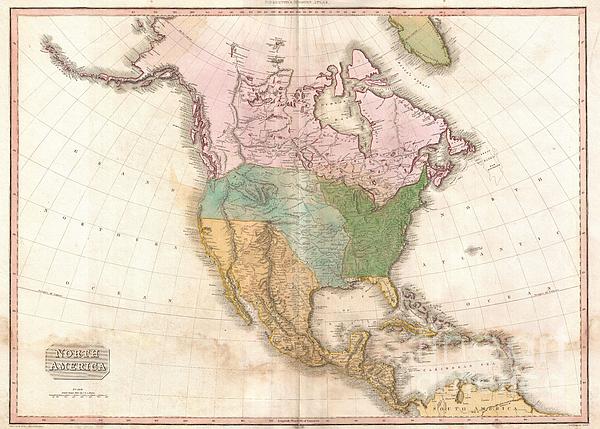
This is an extremely unusual mapping of North America prepared for the 1818 American edition of Pinkerton's Atlas. Although the basic engraving... more
Ships Within
2 - 3 business days
Average Rating (4.84 Stars):


Elaine Brown
April 17th, 2024

Will use as a Christmas card this year!
Elaine Brown
April 17th, 2024

Will use this at Christmas time!
Elaine Brown
April 17th, 2024

Will use this card for a relatives birthday, as she loves wolves!
Kelly Hoffmann
April 17th, 2024

Ok card
Valerie Charles
April 17th, 2024

Lovely card, recipient very pleased
Valerie Charles
April 17th, 2024

Lovely card
This is an extremely unusual mapping of North America prepared for the 1818 American edition of Pinkerton's Atlas. Although the basic engraving remains identical to Pinkerton's Atlas of 1813, published in London, the coloration has been updated to reflect American sensibilities. Where the British edition leaves the borders in the northwest somewhat vague, this edition draws a specific line roughly along the 50th parallel that descends at an angle west of the Rockies to meet the sea around Mt. Rainier. Further, while the London edition attributes Spanish dominion to all lands west of the Mississippi, this edition identifies Louisiana west of the Red River and south of the 40th parallel. Cartographically Pinkerton's map presents a curious amalgam of Soulard, Escalante, Pike and Lewis and Clark. Wheat suggests that Pinkerton struggled to reconcile conflicting reports from Soulard and Pike, particularly in the Missouri Basin. He introduces the curious convention of showing a dashed line no...
My passion is Photography and Aviation or is that Aviation and Photography ! I hope you enjoy my photographs.

Our return policy is very simple:
If you're not happy with a purchase that you made on FineArtAmerica.com, for any reason, you can return it to us within 30 days of the order date. As soon as it arrives, we'll issue a full refund for the entire purchase price. Please note - Fine Art America does not reimburse the outgoing or return shipping charges unless the return is due to a defect in quality.
Fine Art America sells thousands of pieces of artwork each month - all with a 100% money-back guarantee. We take great pride in the fact that hundreds of thousands of artists have chosen Fine Art America to fulfill their orders, and we look forward to helping you select your next piece!
All greeting cards ship from our production facility within 2 - 3 business days of your order.
$5.16


There are no comments for 1818 Pinkerton Map of North America. Click here to post the first comment.