Looking for design inspiration? Browse our curated collections!

Boundary: Bleed area may not be visible.

The watermark at the lower right corner of the image will not appear on the final product.

by Paul Fearn
$25.00
Size
Bottom Style
Image Size
Product Details
Dress it up, dress it down, or use it to stay organized while you're on the go. Our zip pouches can do it all. They're crafted with 100% poly-poplin fabric, double-stitched at the seams for extra durability, and include a durable metal zipper for securing your valuables.
Our zip pouches are available in three different sizes and with two different bottom styles: regular and t-bottom.
Design Details
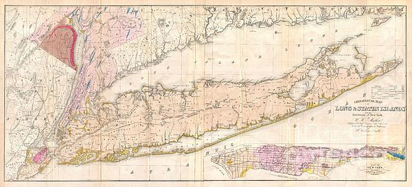
Issued prior to the American Civil War and the subsequent Long Island land rush, this is one of the most detailed and attractive large format maps of... more
Care Instructions
Spot clean or dry clean only.
Ships Within
2 - 3 business days
Average Rating (4.36 Stars):


Rosemary Milazzo
April 14th, 2024

Absolutely love it!!! It is so beautiful and calms and relaxes me every time I look at it. Couldn’t be happier!
Maggie Brewner
April 13th, 2024

I was disappointed that the image on this pouch was not very clear. The zipper doesn't work real well, either.
Dolores Nadwondy
March 25th, 2024

Love this!
Dolores Nadwondy
March 25th, 2024

Great quality
Fred R Manthai
March 7th, 2024

Very attractive. I am very satisfied with this purchase.
Rachel Paschini
March 5th, 2024

Using as a wallet
Issued prior to the American Civil War and the subsequent Long Island land rush, this is one of the most detailed and attractive large format maps of Long Island to appear in the 19th Century. Covers from New Jersey and Staten Island eastward as Montauk and Fisher’s Island. Includes parts of Westchester, New Jersey, Rockland County, and the Connecticut Coast. A large inset map in the lower right hand quadrant depicts Manhattan with a special focus on geological features and topography. Shows the partially completed Long Island Railroad as well as smaller roads and towns. Notes various important Long Island communities including the East Hampton, Bridgehampton, Southampton, Amaganset, Riverhead, and Sag Harbor, among others. In many cases individual buildings are detailed. The whole is laid out on a grid structure of ten mile squares. Prepared by W.W. Mather from the survey work of John Calvin Smith. Engraved by Endicott & Company for part one of Mather’s Geology of New York .
My passion is Photography and Aviation or is that Aviation and Photography ! I hope you enjoy my photographs.

Our return policy is very simple:
If you're not happy with a purchase that you made on FineArtAmerica.com, for any reason, you can return it to us within 30 days of the order date. As soon as it arrives, we'll issue a full refund for the entire purchase price. Please note - Fine Art America does not reimburse the outgoing or return shipping charges unless the return is due to a defect in quality.
Fine Art America sells thousands of pieces of artwork each month - all with a 100% money-back guarantee. We take great pride in the fact that hundreds of thousands of artists have chosen Fine Art America to fulfill their orders, and we look forward to helping you select your next piece!
All zip pouches ship from our production facility within 2 - 3 business days of your order.
$25.00


There are no comments for 1842 Mather Map of Long Island New York. Click here to post the first comment.