20% off all products! Sale ends tonight at midnight EST.
 East As Far As Greenland And Iceland. Inexplicably Greeting Card featuring the photograph 1849 Tallis Map of Canada or British America by Paul Fearn")
Boundary: Bleed area may not be visible.

The watermark at the lower right corner of the image will not appear on the final product.
Inside Message (Optional)
Inside View

by Paul Fearn
Regular Price: $6.45
20% Off (Sale Ends in 14 Hours)
$5.16
Quantity
The more you buy... the more you save.
Orientation
Image Size
Product Details
Our greeting cards are 5" x 7" in size and are produced on digital offset printers using 100 lb. paper stock. Each card is coated with a UV protectant on the outside surface which produces a semi-gloss finish. The inside of each card has a matte white finish and can be customized with your own message up to 500 characters in length. Each card comes with a white envelope for mailing or gift giving.
Design Details
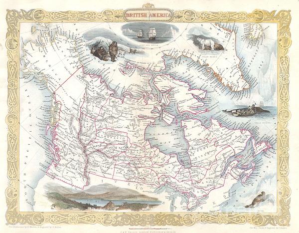
This is a rare and curious first state first edition of Tallis’s 1849 map of British America or what is today Canada. Extends from Russian America... more
Ships Within
2 - 3 business days
Average Rating (4.84 Stars):


Elaine Brown
April 17th, 2024

Will use as a Christmas card this year!
Elaine Brown
April 17th, 2024

Will use this at Christmas time!
Elaine Brown
April 17th, 2024

Will use this card for a relatives birthday, as she loves wolves!
Kelly Hoffmann
April 17th, 2024

Ok card
Valerie Charles
April 17th, 2024

Lovely card, recipient very pleased
Valerie Charles
April 17th, 2024

Lovely card
This is a rare and curious first state first edition of Tallis’s 1849 map of British America or what is today Canada. Extends from Russian America ( Alaska ) east as far as Greenland and Iceland. Inexplicably, this map recognizes the British claim to Oregon as far south as the Columbia River. This dispute was supposedly resolved three years previously in 1846 by the “Oregon Treaty” which officially set the U.S – British America border at the 49th parallel. Features numerous decorative vignettes typical of Rapkin / Tallis work including a seal, whale fishing, the exploring ships Fury and Recla, a polar bear, some Esquimaux (Eskimos) and a view of Boston. Later versions of this map would replace the Boston view and update the political geography of the Oregon region (called New Georgia here). This particular version never made it into the Tallis’s important 1850 atlas, instead it was issued exclusively for the 1849 edition of Hinton’s History and Topography of the United Stat...
My passion is Photography and Aviation or is that Aviation and Photography ! I hope you enjoy my photographs.

Our return policy is very simple:
If you're not happy with a purchase that you made on FineArtAmerica.com, for any reason, you can return it to us within 30 days of the order date. As soon as it arrives, we'll issue a full refund for the entire purchase price. Please note - Fine Art America does not reimburse the outgoing or return shipping charges unless the return is due to a defect in quality.
Fine Art America sells thousands of pieces of artwork each month - all with a 100% money-back guarantee. We take great pride in the fact that hundreds of thousands of artists have chosen Fine Art America to fulfill their orders, and we look forward to helping you select your next piece!
All greeting cards ship from our production facility within 2 - 3 business days of your order.
$5.16


There are no comments for 1849 Tallis Map of Canada or British America. Click here to post the first comment.