20% off all products! Sale ends tonight at midnight EST.

Boundary: Bleed area may not be visible.

Inside Message (Optional)
Inside View

by Nasa
Regular Price: $25.00
20% Off (Sale Ends in 22 Hours)
$20.00
Quantity
The more you buy... the more you save.
Orientation
Image Size
Product Details
Our greeting cards are 5" x 7" in size and are produced on digital offset printers using 100 lb. paper stock. Each card is coated with a UV protectant on the outside surface which produces a semi-gloss finish. The inside of each card has a matte white finish and can be customized with your own message up to 500 characters in length. Each card comes with a white envelope for mailing or gift giving.
Design Details
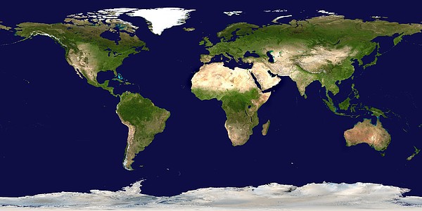
Whole Earth map based on satellite data. This is a mosaic of numerous satellite observations of the Earth. Land colours are shaded using topographic... more
Ships Within
2 - 3 business days
Average Rating (4.84 Stars):


Maggie Brewner
April 13th, 2024

This card was done perfectly.
Michael Bryant
April 13th, 2024

Ordered for a UK client. The quality of the greetings cards was excellent and delivery was quick.
Michael Bryant
April 13th, 2024

Ordered for a UK client. The quality of the greetings cards was excellent and delivery was quick.
Michael Bryant
April 13th, 2024

Ordered for a UK client. The quality of the greetings cards was excellent and delivery was quick.
Leslie Denkers
April 12th, 2024

The artwork is beautiful. I think it would be excellent on a canvas. I have been considering a second order. I am in awe of the artist.
Lois Teegarden
April 12th, 2024

I have not received the sandhill crane framed print yet/ cannot submit a review yet.
Whole Earth map based on satellite data. This is a mosaic of numerous satellite observations of the Earth. Land colours are shaded using topographic data. The land is dominated by vegetation (green) or arid land (brown) such as the deserts of North Africa. The sea ice in the polar regions has not been shown, revealing details of the Antarctic and Arctic coasts. The surface colour of the oceans is shown. Sandy shallow seas, like the Great Bahama Bank (upper left) are light blue. This image uses cloud-free MODIS (Moderate Resolution Imaging Spectroradiometer) data from June-September 2001. Antarctica was imaged by AVHRR (Advanced Very High Resolution Radiometer) data.
Science Photo Library (SPL) is the leading source of science images and footage. Sourced from scientific and medical experts, acclaimed photographers and renowned institutions, our content is unrivaled worldwide. Outstanding quality, accuracy and commitment to excellence are deeply embedded in our DNA. Science Photo Library inspires creative professionals and delivers engaging content of the highest quality for a wide range of clients in a variety of sectors. Visit sciencephoto.com for more information and stay connected on Twitter, LinkedIn, Instagram and Vimeo.

Our return policy is very simple:
If you're not happy with a purchase that you made on FineArtAmerica.com, for any reason, you can return it to us within 30 days of the order date. As soon as it arrives, we'll issue a full refund for the entire purchase price. Please note - Fine Art America does not reimburse the outgoing or return shipping charges unless the return is due to a defect in quality.
Fine Art America sells thousands of pieces of artwork each month - all with a 100% money-back guarantee. We take great pride in the fact that hundreds of thousands of artists have chosen Fine Art America to fulfill their orders, and we look forward to helping you select your next piece!
All greeting cards ship from our production facility within 2 - 3 business days of your order.
$20.00


There are no comments for Whole Earth Map. Click here to post the first comment.